23 Aug, 2015
Sea-locked Indonesia to stress maritime advantage as main development sector
Jakarta (ANTARA News) 21 August 2015 – Indonesia is one of the worlds largest maritime countries, with some 5.8 million square kilometers of sea territory, while its land territory covers only 1.9 million square kilometers.
Its coastline is some 92 thousand kilometers long, making it the second-longest after Canada. The country is the largest archipelagic nation in the world, as around 70 percent of its total territory is water, and it has 17,480 islands.
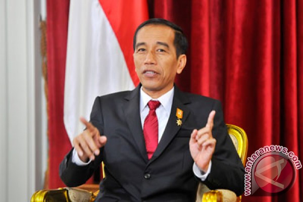
 President Joko Widodo (Jokowi) during a special interview with the Antara news agency, LPP RRI and LPP TVRI on August 12, 2015. (ANTARA/Yudhi Mahatma) |
The government, therefore, has identified the maritime sector as one of its main sectors for development.
“We have so far ignored them and never given them attention while the fact is that two thirds of the Indonesian territory are waters and it is a huge potential,” he said in an interview with Antara news agency, state-owned TVRI and state-run RRI on August 12, 2015.
He said one way to boost the countrys economic growth was infrastructure development to smooth distribution of goods by land and sea.
“We wish to start paying attention to it, develop it physically and build shipyards as interconnection between the islands is very important in addition to maritime education,” he said.
He said among big seaports to be built are Kuala Tanjung measuring 2,000 hectares, Tanjung Priok whose capacity will be increased to accommodate bigger flows of goods, Teluk Lamong in Surabaya, Makassar port in South Sulawesi and Sorong port in Papua.
Besides, the government is also focusing on the construction of the sea express transportation project to improve the condition of Indonesias maritime economy.
“One of our most important goals is the realization of the sea express transportation project. The sea express transportation system is among the maritime infrastructure facilities that will be supported by productive shipbuilding industries in Indonesia,” Jokowi stated on August 14, 2015, in his state of the nation address to commemorate Indonesias 70th Independence Day.
The nation must re-explore Indonesias maritime culture to achieve sovereignty in the sector that is supported by good economic conditions and abundant resources, Jokowi emphasized.
“Indonesia is a maritime nation. It must preserve and utilize its marine resources seriously. This way, we can realize the international maritime axis program to strengthen our national, regional and global position,” he remarked.
The government, he added, is processing the strategy of the maritime axis program to be implemented as the Indonesian National Maritime Policy.
Furthermore, Jokowi called on all stakeholders to do their utmost to save oceans from the impacts of climate change, which threatens maritime resources and fisheries in the country.
“Oceans that face the threat of climate change must be saved,” he said.
Having been in power for less than a year, President Jokowi on August 12, reshuffled his cabinet by among other thing appointing Rizal Ramli as new coordinating minister for maritime affairs and resources, replacing Indroyono Susilo.
Rizal Ramli has expressed his optimism that Indonesia could be number one in marine tourism in the world if the country could preserve the beauty of its seas.
He recently launched a program of Expedition of a Million Ridges of Rock as earlier announced by President Joko Widodo to add beauty to the countrys sea tourism.
“We will provide apartments for fishes. In five years the apartments in ridges of rock would grow taller. There would be more fishes that our fishermen do not have to go far fishing,” he said.
The ridges of rocks would also be useful for the military as addition barriers against enemy war ships, he said.
He said Indonesia said Indonesia should be able to compete against other countries which have made a living from sea tourism such as the Maldives and Thailand.
“The Maldives is nothing compared to Indonesia (in sea tourism potential),” he said.
In the meantime, Minister of Maritime Affairs and Fisheries Susi Pudjiastuti has instructed that researches conducted by the ministry should be in accordance with the world maritime axis concept.
“I expect researchers and engineers of the Marine and Fisheries Research and Development Board to take up the role and disseminate their findings to make Indonesia the world maritime axis,” she said recently.
She added that about a year ago, the board had produced many innovations in marine and fisheries technology that benefited stakeholders and the community.
These innovations were the e-Logbook, e-Observer, Smart Fisherman Information System and the Community Salt Information System (SiTEGAR), among others.
The e-Logbook replaced conventional logbooks and made the process easier, faster and more accurate.
She explained that the Smart Fishermen Information System is an android application that integrated information on fish prices, weather and ocean dynamics.
The Community Salt Information System is a web-based system that gives information on salt production across the country. It also provides reports and data on Peoples Salt Business Empowerment groups in Indonesia.
Head of the ministry’s Marine and Fisheries Research and Development Board Achmad Purnomo emphasizedthat Indonesia has economic potential of US$800 billion per year in the field of marine and fisheries resources.
This economic potential in Indonesia is expected to be able to provide employment opportunities to some 40 million people.
“Geographically, Indonesia is located between two continents and two oceans. Therefore, it deserves to be the world maritime axis, which can be instrumental to develop the global economy and industry,”
However, the extraordinary potentials have not yet been optimally exploited.


Liked this article? Share it!